
1. Multi-Well Cross-Sections & Stratigraphic Frameworks
Well Log Correlation is the foundational methodology of petroleum geology and reservoir characterization. By comparing wireline and LWD logs across multiple offset wellbores, geoscientists map the lateral continuity of reservoir pay sands, identify structural fault throws, delineate depositional facies (such as channel incisions, carbonate shoals, and barrier bars), and establish basin-wide chronostratigraphic frameworks.
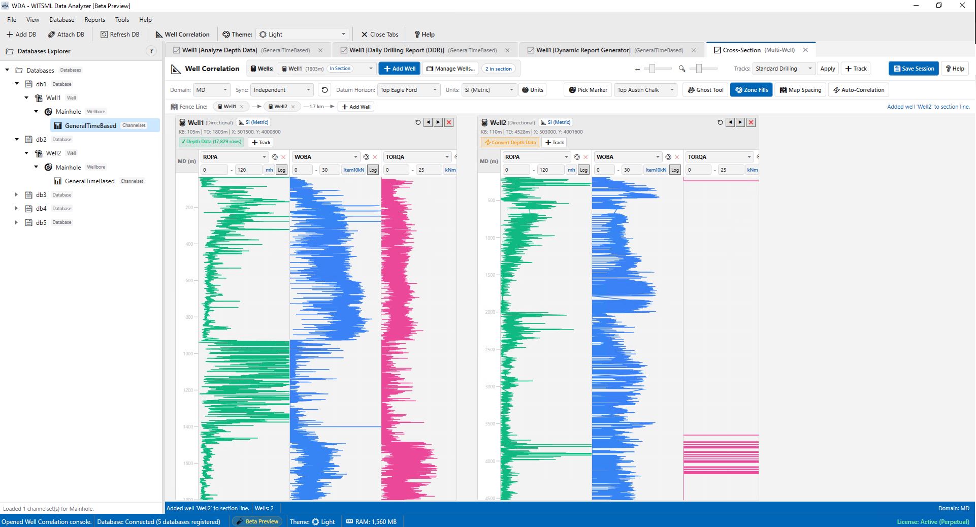
The WDA Well Correlation Console (accessed directly from the top menu via Reports > Well Correlation Console... or the Well Correlation toolbar button) provides an interactive environment for constructing multi-well cross-sections. Interpreters can load unlimited offset wells, synchronize depth tracks across multiple coordinate domains (MD, TVD, TVDSS, TVT), execute Stratigraphic Datum Flattening on any formation top, deploy interactive Ghost Curves with real-time stretch/squeeze adjustments, and utilize automated mathematical pattern matching powered by Normalized Cross-Correlation (NCC) and Dynamic Time Warping (DTW).
2. Structural vs. Stratigraphic Datum Flattening
Understanding geological history requires switching between structural elevation and depositional time planes:
-
Structural Cross-Sections (TVDSS):
Aligns all wells relative to True Vertical Depth Subsea (TVDSS) referenced to Mean Sea Level. Illuminates structural trap geometries, regional structural dip, fault displacements, and fluid contact elevations (gas-oil contact, free water level). -
Stratigraphic Datum Flattening:
Vertically shifts all wellbores so a chosen geological marker aligns horizontally atDepth = 0. Flattening on a chronostratigraphic datum (e.g., a regional marine flooding surface or volcanic ash marker) removes post-depositional tectonic folding, revealing original depositional thickness, channel incisions, and reservoir sand pinch-outs. -
Synchronized Depth Domains:
Toggle instantly between Measured Depth (MD), True Vertical Depth (TVD), True Vertical Depth Subsea (TVDSS), and True Vertical Thickness (TVT).
3. Interactive Ghost Curve Transformation Tool
Correlating electrofacies between distant wells requires flexible visual comparison. WDA features a dedicated Ghost Curve Tool:
-
Translucent Movable Overlay:
Select a high-confidence Type Well as the reference source and cast its Gamma Ray or Resistivity log as a translucent "ghost" over the target drilling well. -
Interactive Depth Translation (-100 m to +100 m):
Slide the horizontal offset controller to vertically translate the ghost curve across the target log, compensating for regional subsidence, faulting, or structural elevation deltas. -
Stretch / Squeeze Scaling (0.50x to 2.00x):
Interactively stretch or compress the vertical scale of the ghost curve to model depositional expansion (formation thickening) or condensation (stratigraphic thinning). -
One-Click Pick Transfer:
Once curves are visually aligned, click Drop Picks on Target. WDA automatically projects all formation tops from the type-well onto the target wellbore at their exact mathematically transformed depths.
4. Automated Signal Cross-Correlation (NCC & DTW)
Eliminate human bias and automate log matching using integrated mathematical pattern algorithms:
-
Normalized Cross-Correlation (NCC):
Computes Pearson correlation coefficients (r = 0.0 to 1.0) across continuous sliding depth lags. A sharp correlation peak mathematically confirms the exact structural vertical shift between offset wells. -
Dynamic Time Warping (DTW):
Applies non-linear alignment algorithms that accommodate uneven sedimentation rates, localized facies thinning, and depositional hiatuses without manual point-by-point stretching. -
One-Click Optimal Shift Application:
Directly apply the calculated correlation peak lag to the Ghost Tool with a single button click, aligning the logs instantly.
5. Fence Line Ribbons & Translucent Zone Fills
-
Dynamic Fence Line Ribbon:
An interactive header ribbon displays the sequential arrangement of wells, wellhead coordinate distances, and inter-well spacing (e.g.— 1,420 m ➔ —). -
True Map Distance Scaling:
Toggle between equidistant column widths and Map Spacing, which scales horizontal canvas distance proportionally to real-world easting/northing coordinates. -
Translucent Geological Zone Fills:
Renders color-coded polygonal ribbons connecting matched formation tops between adjacent wells, providing instant visual clarity on structural dips and reservoir thickness trends.
6. Related WDA Engineering Modules
- WDA: WITSML Compatible Data Analyzer: Explore WDA's columnar architecture and integrated wellbore tools.
- Depth-Based Log Analysis & Petrophysics: Evaluate individual single-well petrophysical depth tracks.
- Dynamic Report Generator & Crossplots: Build multi-parameter crossplots and composite lithology logs.
- Data Export Console: Export correlated depth logs to CWLS LAS 2.0/3.0 or Parquet.
The WDA Cross-Well Stratigraphic Correlation Console provides petroleum geologists with a robust, mathematically rigorous environment to build confident subsurface geological models.